 |
| Arrow Canyon Range with pylon and agave |
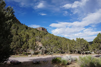
And finally, the last stretch of road. At this time of day, we drive with a careful eye out for deer crossing. This time, we turned east just north of Pioche and gradually climbed a small paved road into a river valley that has cut its way through lava ash tuff. The broad valley narrows quite abruptly and the road crests and dips like a mule trying to shake its rider. On either side, pinon and juniper, then a few houses, then volcanic rock soaring above on either side, grassy meadows, lines of trees showing where the water runs. Our destination was the Horsethief Gulch campground at Spring Valley State Park.
 |
| Easier to describe than to photograph! |
by lamplight, and enjoyed a very mild evening - lying on a blanket and watching the stars brighten as the daylight slowly faded. We saw numerous satellites and several planets as well as the Milky Way. It was a perfectly clear evening. The late arrival of neighbours with trucks shining headlights straight towards our site put an end to our night vision; we went to bed.
 |
| Ranch Campground |
 |  |  |
|---|---|---|
| Eroded holes? or MOUTHS?!! | Volcanic rock down a crazy steep hillside | Intrepid! |
I have to describe Spring Valley (and the Eagle Valley reservoir) as yet another under-visited jewel in Lincoln County. The upper valley was seasonally occupied five thousand years ago or more, and then, much more recently, farmed by Mormon settlers in the second half of the 19th century. The park headquarters are in one of the old ranch houses. The lower valley, a couple of miles below the park at Ursine (great name!), is still farmed and many of the yards show a neatness that, rightly or wrongly, I associate with Mormon households.
 |
| Eagle Valley Reservoir |
In the mid 1960s, the valley was dammed for agricultural purposes. The reservoir has since been
stocked with rainbow trout and we saw quite a number of people fishing while we were there. Theoretically there's swimming too, but up close, the water had a foul smell to it and what looked like an algal bloom - we left it to the fish and fisherfolk.
It is a beautiful spot though ...
 |  |  |
|---|---|---|
| Three views from our campsite at Horsethief Gulch Campground, Spring Valley State Park NV | ||
... so beautiful that only a very great curiosity took us into Pioche where we spent much of the day.
Itinerary
Friday: 93 from Henderson to Pioche, 322 to Spring Valley State Park.
No comments :
Post a Comment
Note: Only a member of this blog may post a comment.